New Clues, New Focus

In recent weeks, four new pieces of debris have been found.

Two, in Mozambique, which have now been confirmed as belonging to MH370.

The first, a triangular piece with No Step stencilled on that appears to be consistent with part of the horizontal stabiliser in the tail section. This was found by American Lawyer, Blaine Alan Gibson, on the Paluma Sandbank off the coast of Mozambique on 27 February 2016.

The second, which is clearly marked 676EB is a fairing access hatch found by South African teenager Liam Lotter while on holiday in Mozambique in December 2015. He came forward with this find after seeing pictures of Mr Gibsons piece and realising the significance of what he himself had found.

The third piece, part of an engine cowling and clearly showing the Rolls Royce logo was found by Archaeologist, Niels Le Roux Kruger on the beach at Mossel Bay, South Africa on 24 March 2016.

The fourth part, found by holidaying couple, the Vitrys, on the beach next to the Mourouk Ebony Hotel on the south coast of Rodrigues Island, Mauritius, appears to match part of an internal bulkhead consistent with 9M-MRO.

The location of these finding do indicate strongly that the flight ended not near Sumatra, but somewhere in the Southern Indian Ocean rather than the Northern, and probably much closer to the African continent and further north than the current search area.

Posted in Uncategorized | Tagged , , , , | Leave a comment

MH370: A series of bad luck?

Please refer to the Factual Information report issued on 8 March 2015, point 1.7.2.3

Volcanic Ash Advisories issued by Darwin Volcanic Ash Advisory Centre (VACC) on 07March 2014 at 06:27 and 18:37 UTC for Sinabung (Sumatra, Indonesia) highlighted volcanic eruption located at 3.10°, N 98.23°E (Figure 1.7E above) and volcanic ash plume observed up to a height of 12,000 ft. (FL120) and the plume was extending toward the west.”

Figure 1.7E clearly shows a predicted ash cloud along the West Coast of Sumatra.

Was this advisory given to all pilots that night? Was Captain Zaharie given this advisory and why would he be if his flight was from Kuala Lumpur to Beijing, an opposite route to any need for information about Mount Sinabung?

I have long believed that MH370 was a horrible accident, perhaps due to a fire onboard in the region of Igari. I further believe that the initial event started a series of other unforeseen problems that resulted in the failure of the aircraft and an ending on the West Coast of Aceh.

I am aware that the radar covering the Aceh region that night was not operational, it was routinely switched off at midnight due to budget restraints. Indonesia could not have seen MH370.

Today, Geomar held a press conference and clearly demonstrated that there is a possibility that the flaperon found on Reunion Island and believed to be from MH370, pending more testing by the BEA, did start its journey on the west coast of Sumatra or Java.

As ever, I ask questions, I do not claim to have any answers.

My thoughts and prayers are with the families of all the passengers on board MH370.


Posted in Uncategorized | Tagged , , , , | Leave a comment

MH370: Seismic event recorded by the University of Science and Technology, China

While I have never claimed that the location I have flagged as potentially being an end point for MH370 is anything more than my own speculation, and I am certainly not an expert, I am increasingly compelled by the facts I continue to learn about in the region that seemingly give this some support when they are looked at together.

Today I took another look at the ‘seismic’ event that was recorded and analysed by the University of Science and Technology, China. This event took place at 18:55 UTC on 7 March 2014, this is a very reasonable fit with the potential of the plane being there if we ignore the much maligned Inmarsat data.  It also fits with the timing of MH370 if a route was taken from Penang to this location across Aceh.

I am aware that the radar covering Aceh was not operational after midnight on this night, both military and civilian.  When Indonesia says it did not see this plane it is because they could not have done.

This map was misread by the press when issued.

The red star is the location of the Chinese underwater detector, the circle West of Aceh and encompassing the area 75 miles West of Meulaboh is the location of the seismic event.

The full report can be read here (translation required).

http://seis.ustc.edu.cn/News/201403/t20140314_191123.html

University of China Seismic map

This is not the same location as the seismic event recorded by the Curtin Centre for Marine Science and Technology in Australia.

I also noted that images (below) captured by a Thai Satellite are almost identical to the ones I am flagging, albeit the sun being at a different angle due to the fact these were taken of possible debris in the Southern Indian Ocean and the ones I am flagging are only 4 degrees North of the Equator so the sun was almost overhead.

Thai Satellite images of debris in Southern Indian Ocean

I will keep researching, keep writing and let those reading this blog make up their own minds.

The most important thing is to continue praying for the families of those on this flight.


Posted in Uncategorized | 1 Comment

MH370: Sifting the wheat from the chaff

Since MH370 disappeared just over one year ago, the mystery has generated a deluge of possible theories, unqualified claims, spoof scenarios and self nominated experts claiming to have found the plane simply because a wave on a satellite picture was shaped like one.

Quite simply, nobody knows where the plane is or why it is there.

Reading the recently released transcript of the Kuala Lumpur Air Traffic Control operator and learning that his supervisor was asleep on duty the night the plane went missing it seemed obvious to me that the Malaysian Authorities have been playing catch up ever since. Were they reluctant to give full details of the incompetence of those under the under the authority of Government, of course. However, I doubt they know where the plane is and are covering it up as some suggest.

Some of the theories, even the spoof ones, have been quite plausible, especially those written by those with the knowledge of Boeing planes such as pilots, air accident investigators or the maths skills that involve words I can’t even pronounce! However, they do not have access to the full information the official investigation team do such as the full raw Inmarsat data so are all working with one arm tied behind their backs.

Others have no experience, they just mean well, they have their pet theory, argue with experts who try to explain the realities of their claim and then start a conspiracy theory of their own in the vain hope that if lots of folks believe and support them they must be right and their theory is justified. Twitter is of course a ripe breeding ground for such things.

I totally support the right to free speech, I also admire those who have been so diligent in their work to find MH370 such as the members of the Independent Group.

If the search in the Southern Indian Ocean is abandoned in May as predicted, I truly hope that the authorities will revisit the witness accounts of Kate Tee (who was sailing in the area north of Aceh on the night), a cafe owner Hasbi from Aceh and Mike McKay (who was on an oil rig in the South China Sea) will be taken seriously and all other information that is not related to the Inmarsat data will be reviewed and those locations flagged by this are searched with the same resource and effort afforded to the Southern Indian Ocean.

As a fan of CSI and NCIS I have learned the correct approach is to follow the evidence, if the evidence does not fit, no wild speculation is going to make it a fact.

I continue to pray for the families.

Posted in Uncategorized | Leave a comment

MH370: One Year Later

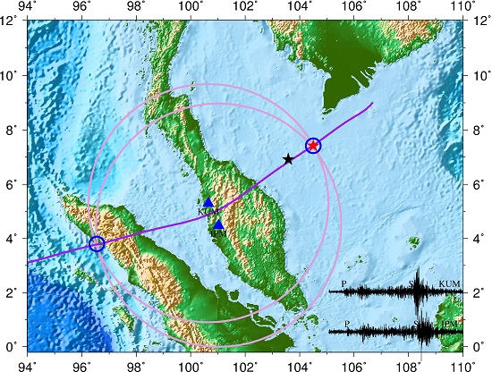
I clearly remember waking on the morning of Saturday 8 March, turning on the news and learning that a Malaysia Airlines plane was missing on route from KL to Beijing.

I remembered my own last flight on MAS from KL to London when I sat at the window seat with the parents of a stewardess next to me. They spoke little English but were so kind, their daughter kept sneeking them snacks which they shared with me.

I thought of those parents that morning, was their daughter on this flight? How many other parents just like them were sitting by the phone at that moment? I was glued to Sky News the entire weekend, I assumed the plane must have crashed in the Gulf of Thailand and it might take a few days to find it.

Little did I know that a year on the plane would still be missing and like that first weekend I would remained glued to information sources and Twitter with an inexplicable need to know where the plane is and how it got there.

I suffer from terrible ear pain when landing on a flight. My eyes start pouring and it can be a bit disorientating. This wonderful mum sitting next to me on that flight simply held my hand and nodded in support.

I wished there was a way I could do something to help those affected by the missing MH370 but all I could do was watch TV, read Twitter and wait.

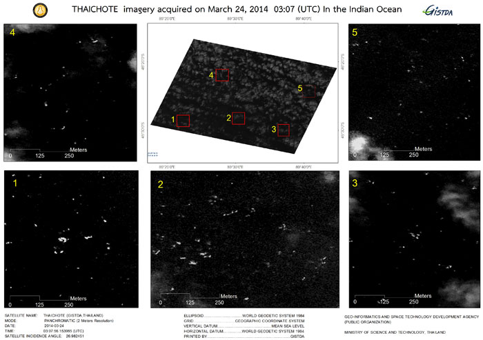
Then I read about Tomnod and realised there was something I could do as these crowdsourcing folks were asking for help. I joined up and spent a rather obsessive amount of time looking through map frames, flagging oil rigs and boats as ‘other’ in the context their location on a given day may be helpful at some point…didn’t have a clue about the fact they are monitored anyway etc.

I was newish to Twitter, I mostly read things and actually tweeting felt like a big deal despite being careful about using my real name – too may oddballs out there!

Before long I was following folks with an interest in MH370, and tweeting away. I gained confidence to flag the images I had flagged and before long I was emailing with folks to ask a bundle of questions.

I started this blog, I flagged what I felt I had to flag and I am satisfied that the authorities have taken my input seriously, including the Chief of the Royal Malaysian Navy who said these images will be studied.

Is this location where MH370 ended its journey, I do not know. I am an office worker from the UK, not an expert in Geospacial Science. Are these images of objects reflecting the sun, yes, I have had feedback to say so but that does not mean these objects are related to MH370. They do however support the witness accounts of Kate Tee and Hasbi from Aceh if MH370 ended its journey 75 Miles West of Meulaboh. Did these objects wash out to the wider sea as did much of the Aceh debris from the Tsunami?

As we approach the 8 March a year on, I can only continue to pray for the families who have lost so much and remain in the limbo of the unknown.

Posted in Uncategorized | Tagged , | Leave a comment

MH370 – How not to manage a press announcement!

On 29 January 2015 the Malaysian Department of Civil Aviation announced, in a rather shambolic way, that they were declaring the plane was lost and all on board were dead.

This was nothing more than a legal move to enable the compensation process for the families of those on board this plane to commence. The search for the plane and the criminal investigation are still continuing.

The Malaysian Government had ten months to plan for this communication and had promised the families would be briefed in advance of any such announcements. This did not happen, only the families of the 50 Malaysian passengers represented by Cry For Truth (Voice 370) had this information in advance and issued a press release via Facebook the day before which was also Tweeted.  This led to other families, mainly Chinese, asking who Cry For Truth are and saying they do not represent them.  I have been in contact with three of these Chinese relatives on Twitter but know it is not widely available in China.

The Malaysian Government assured the media that the families were being briefed in advance but sadly the families themselves say otherwise and at least one man whose Chinese wife was on MH370 was told to watch the announcement on TV news.

Some of the family members who were told about the press conference turned up, as any of us would. As a result the press conference was cancelled as it was deemed inappropriate the family members were present. Surely, they were more relevant than the media reps? The other family members simply got a text just before the planned announcement so had no way of being there and certainly had no briefing.

Sadly it begs the question that if the Malaysian Government cannot manage a simple communication plan, how can they manage a major investigation?

I am open to ideas on what the images I am flagging may be. I can confirm the Chief of the Malaysian Navy has said they are worth studying and will be studied. I hope the search does not end before all leads have been pursued, the families deserve that.

75 Miles West Meulaboh

Items in the sea West of Meulaboh on 9 March 2014 reflecting the sun

Items in the sea West of Meulaboh on 9 March 2014 reflecting the sun


Posted in Uncategorized | Leave a comment

No Stone Unturned – Just Boulders

Please read this with reference to my two other blog stories on the subject of MH370 for screen shots and context.

I have some questions for the Malaysian Government, who promised that no stone would be unturned in the search for MH370, yet put all their focus into the search off Australia, at huge expense to Australia when the UK company, Inmarsat, came up with it’s ping data.

At this point the official search had only reached the Andaman and Nicobar Islands, the East coast of Sumatra in the Malacca Straits and stopped short of the West Coast of Sumatra.

236 people flagged potential debris 75 miles West of Meulaboh in Aceh, Indonesia according to the Tomnod results from satellite images taken at 11am local time on 9 March 2014. That made it a key area of interest by their own results map. Was this ever followed up by the authorities that Tomnod sent the data to in good faith?

Why was the search of this region suspended before reaching the West of Sumatra? Was the Inmarsat data considered so foolproof when 10 months later we have no evidence to support it?

I am not an aviation expert, I have no idea why MH370 would be West of Sumatra but I am intelligent enough to suggest that a 777 would need to circle and lose fuel before an emergency landing. If that plane had no comms for whatever reason a skilled pilot would look for an area off radar so as not to be a threat to any nation and away from flight routes? The West coast of Aceh would be the nearest option for this surely?

The Inmarsat report does not rule out a scenario whereby the plane circled, they have added in a lot of speculation to their calculations to say it was flying in a straight line if indeed it was still in the air for as long as they claim.

Was Captain Zahari expecting to see a military escort to enable him to land a potentially troubled plane at either KL or Banda Aceh? Was he circling to land blind and dark at Banda Aceh hoping the plane would be recognised as non threatening, knowing this airport had less traffic? Did he know the damage to the plane was so bad they could not land and therefore stayed off the West Coast of Sumatra to avoid casualties on the ground?

There is no theory here, just a lot of questions.

I suggest these questions are considered by those with the expertise and authority.

Again, my only wish is to find the plane and bring a chance for the families to end this terrible limbo.


Posted in Uncategorized | Tagged , , , , , | Leave a comment

Update story: Did MH370 go down 75 miles west of Meulaboh?

Since writing my original blog, I am pleased to say that there is now some interest in following up the images I have flagged.

The ATSB (Australian Transport Safety Board) leading the search in the Southern Indian Ocean have passed these images and the Digital Globe catalogue information for the raw images, which was given to me by Tomnod, to the Search Strategy Working Group and I have been assured their own ATSB researchers will look into this as well.

To clarify, I am not claiming this is MH370, I am asking if the images were ever viewed by the relevant authorities once they were passed to them.

The location of these map frames is 4.030521,95.000345 from an image taken with WorldView 1 on 9 March 2014.  This is 75 miles due West of Meulaboh in Sumatra.

DigitalGlobe catalog ID: 102001002C8BA400.

For the sake of the families of those on board MH370 I believe all potential leads should be pursued until the plane is found.


Posted in Uncategorized | 1 Comment

Did MH370 go down West of Meulaboh?

Ten months since the disappearance of MH370 on route from Kuala Lumpur to Beijing, the plane is still missing and the pain of the families remains compounded by the confusing mix of known facts, scientific speculation and conspiracy theories.

I am not a scentist, pilot or air crash investigator, I just joined the internet search on Tomnod like many others and flagged the things I found.  Ten months on I continue to flag these images as the area these images are from (the day after MH370 went missing) was never searched.

Further, the eye witness account of a British sailor claiming to see a plane on fire going south of her boat would put the location exactly where these Tomnod images are from.

A second eye witness in Aceh, saw a plane on fire in the same location but was dismissed by the Indonesian police.  He remains convinced of what he saw.

All I ask is that folks take a look at these pictures because if this is the debris of MH370 then it is a long way from the current official search area and must be worth an underwater search?

First, the location of the debris according to the Tomnod Map Locator, posted on Twitter:

Approximately 70 miles west of Meulaboh in Aceh, Indonesia

Approximately 70 miles west of Meulaboh in Aceh, Indonesia

Second, a Tomnod image in this location which appears to show the ‘S’ of the Malaysia Airlines logo and other items reflecting the suns rays – these images were taken around midday on 9 March 2014.

75 Miles West Meulaboh

Tomnod image of items reflecting the sun, including a possibe ‘S’ from plane logo


The third image shows many metallic items reflecting the sun and is the image frame next to the second one.  There is a very wide area of these items reflecting the sun covering more than 50 Tomnod frames of the area.

Items in the sea West of Meulaboh on 9 March 2014 reflecting the sun

Items in the sea West of Meulaboh on 9 March 2014 reflecting the sun

As I have said I am not an expert, I also realise this floating debris will be long gone by now but surely if this is indeed the location where MH370 ended its tragic journey, this will be the place where the black boxes will be found?

  Naieve, maybe, I just hope that one day the families will have the answers they deserve and begin to find some peace.

Posted in Uncategorized | Leave a comment